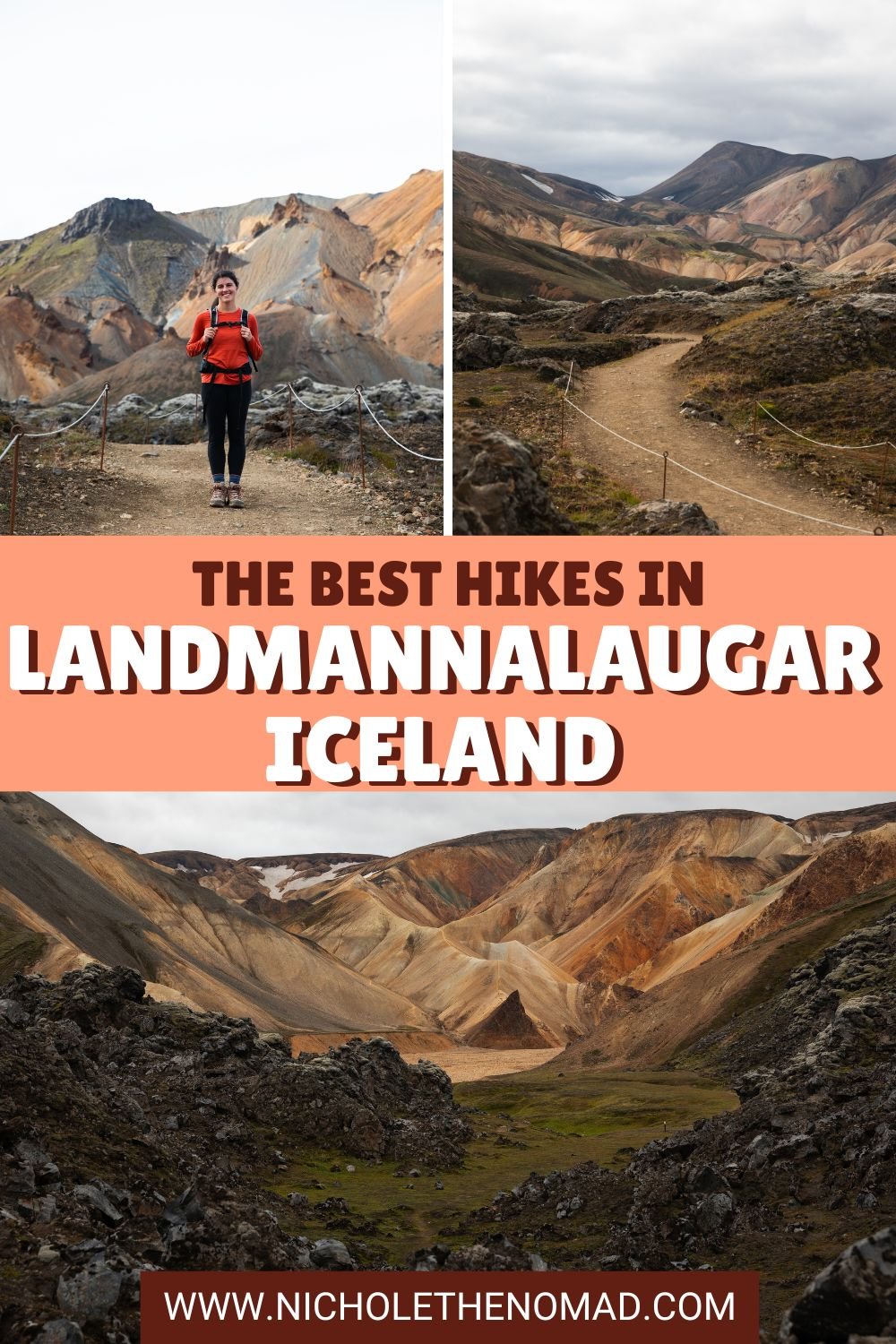
5 Breathtaking Hikes in Landmannalaugar, Iceland
Landmannalaugar is one of the most beautiful areas in Iceland, with so much untouched beauty! It is in a remote area in the highlands and is not easy to get to, but if you are up for a fun adventure, you will not be disappointed.
Landmannalaugar has a diverse landscape, including lava fields, multi-colored mountains, and hot springs. It is one of my favorite places I have visited in Iceland, so I know you will love it. Trust me, it is worth the long drive into the highlands!
And one of the best ways to experience its beauty is by hiking! And the best part? Landmannalaugar has a trail for everyone. Whether you want to enjoy the views from the base of the mountains or hike to the top of one for 360-degree views of the area, you can find the perfect hike in Landmannalaugar for you! This guide has everything you need to know about the beautiful hikes in Landmannalaugar.

Disclaimer: This post contains affiliate links. If you click through and make a purchase, my blog may receive a commission at no additional cost to you.
How to Get to Landmannalaugar
Landmannalaugar is in the highlands of Iceland, so it is not easy to get to. I have visited twice, so I can provide you with the tips to getting there and hiking in its stunning landscapes. Trust me, you will fall in love quickly with Landmannalaugar!
Although there are multiple ways to get to Landmannalaugar, I recommend driving from the north because it is the easiest and does not have river crossings. No matter which you drive, you need a 4x4 approved for F roads. F roads are unmaintained mountain roads with anything from rocks to river crossings.
You can take F26 to F208 and head right into Landmannalaugar pretty easily. F26 is paved, making it easy to drive, but F208 is mostly unpaved. The road is well-maintained compared to when we visited our first time, but it is still very rocky, and you should use caution when driving it.
Just before the camping area in Landmannalaugar, there are two major river crossings. We saw a few people getting towed because their cars could not handle the river crossings. I recommend parking in the lot before the two river crossings and walking over to the trails. The river crossings are deep, so I would avoid trying to cross them. You should also fill up your gas tank before heading into the highlands! The gas stations are few and far between, so having a full tank before the long drive is crucial.
If you do not want to drive, you can take a tour or bus into Landmannalaugar. Quite a few companies offer services in Landmannalaugar, so you do not have to worry about driving on the F roads.
Tips for Hiking in Landmannalaugar
Pack layers and rain gear. The weather in the highlands is unpredictable, making it crucial to pack layers and a rain jacket. The first time we visited Landmannalaugar, the day started beautiful and sunny but quickly turned into a crazy wind and rain storm. The second time, the day started really rainy but eventually turned into a nice overcast day. You should have hiking boots, moisture-wicking clothes, rain jacket, and a hiking backpack with food and plenty of water.
Be prepared for the wind. Both times we visited Landmannalaugar, the wind was pretty crazy, especially if you hike to the top of the mountains. We were happy to have packed layers because the wind makes the temperatures much colder.
Enjoy the hot spring after your hike! After hiking in Landmannalaugar, I recommend taking a dip in the hot springs near the campground. It is the perfect place to relax after a hike.
Always remember to leave no trace. It’s crucial to pack out what you pack in and leave no trash. Some spots have trash bins, so you can easily throw your trash away. If they don’t have trash bins, you can throw your trash away at a nearby gas station or convenience store.
The Best Hikes in Landmannalaugar
Although Landmannalaugar has many beautiful hikes, below are a few of my favorites! As soon as you hike in Landmannalauger, you will fall in love like I did!
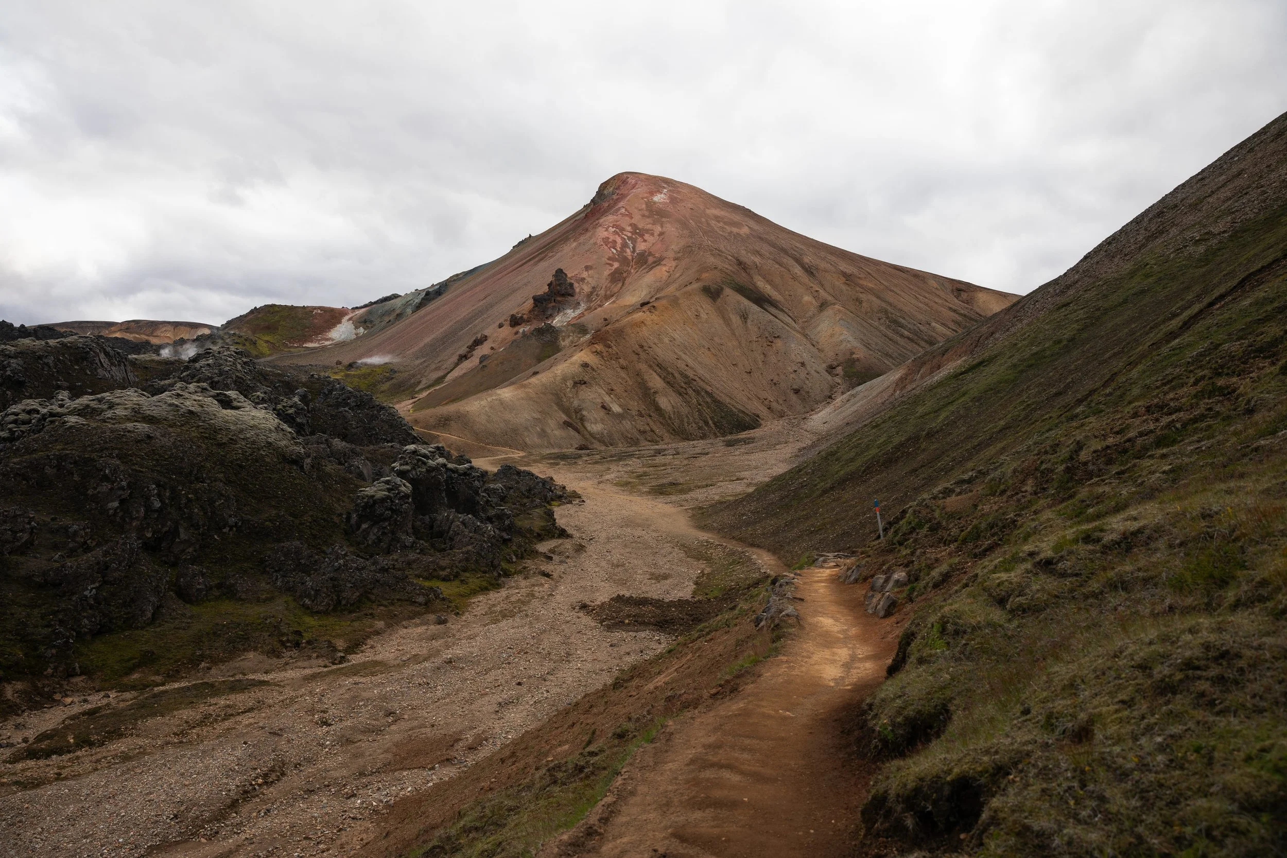
Laugahraun Loop
Length: 3.1 miles
Elevation Gain: 650 feet
Difficulty: Easy/Moderate
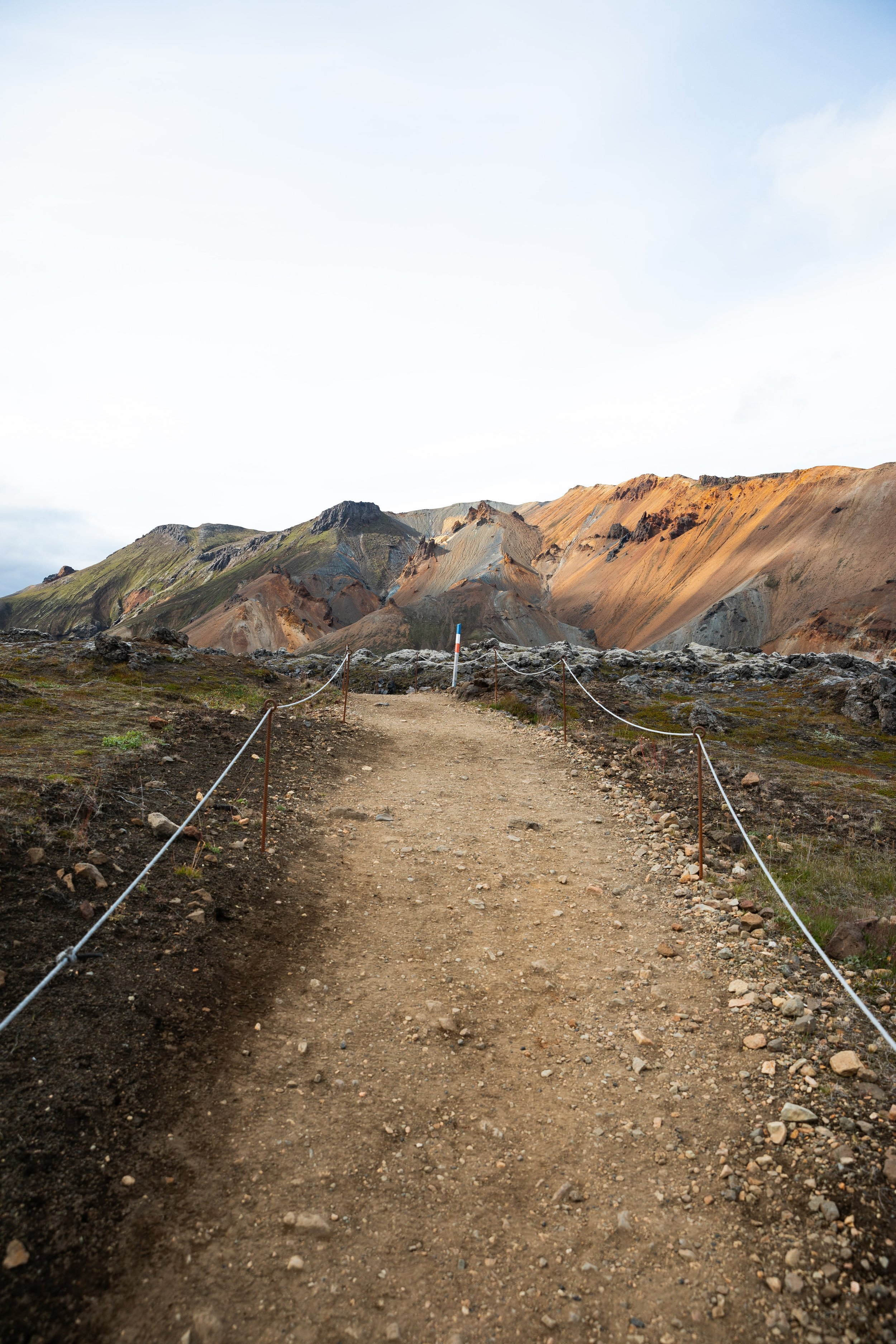
The Laugahraun Loop is the easiest and most popular hike in Landmannalaugar. Although it does not travel to the top of a mountain, it loops around a lava field, providing stunning views of the multi-colored mountains. The views are spectacular, and you will not be disappointed! Although you can hike the loop in either direction, I recommend following it clockwise to save some of the best views for last.
The 3.1-mile loop begins near the information center and hikes behind the Mountain Mall and past the horse area before heading into the lava field. The trail is sometimes hard to follow through the lava field, but just keep an eye out for the trail markers, and you will be fine!
Once you hike through the lava field, you get beautiful views of the surrounding mountains, including Bláhnúkur and Brennisteinsalda. The Laugahraun Loop turns right at the base of Brennisteinsalda, traveling through a geothermal area with some beautiful overlooks. The Laugahraun Loop continues traveling around the base of Brennisteinsalda before approaching a beautiful field with spectacular views of the multi-colored mountains.
The final section of the trail turns right at the field and follows through another small lava field with some of the best views on the trail, in my opinion. The surrounding mountains are just so beautiful, and you can view them along this portion of the trail. Before you know it, the trail connects back to the information center.
The Laugahraun Loop is the perfect hike in Landmannalaugar if you want to enjoy beautiful views without a strenuous hike!


Bláhnúkur Mountain (Blue Mountain)
Length: 5.4 miles
Elevation Gain: 1,500 feet
Difficulty: Difficult
Bláhnúkur Mountain is one of the most hiked mountains in Landmannalaugar! Although it is well-traveled, it is not an easy hike, but the views are worth the effort. There are a few ways to hike Bláhnúkur Mountain, and I recommend hiking it with the Laugahraun Loop. This trail ascends Bláhnúkur Mountain and descends via the right half of the Laugahraun Loop.
The 5.4-mile hike begins at the information center and follows the trail to the left behind the Mountain Mall and past the horse area. The trail splits, following to the left at the trail junction to begin the ascent to Bláhnúkur Mountain.
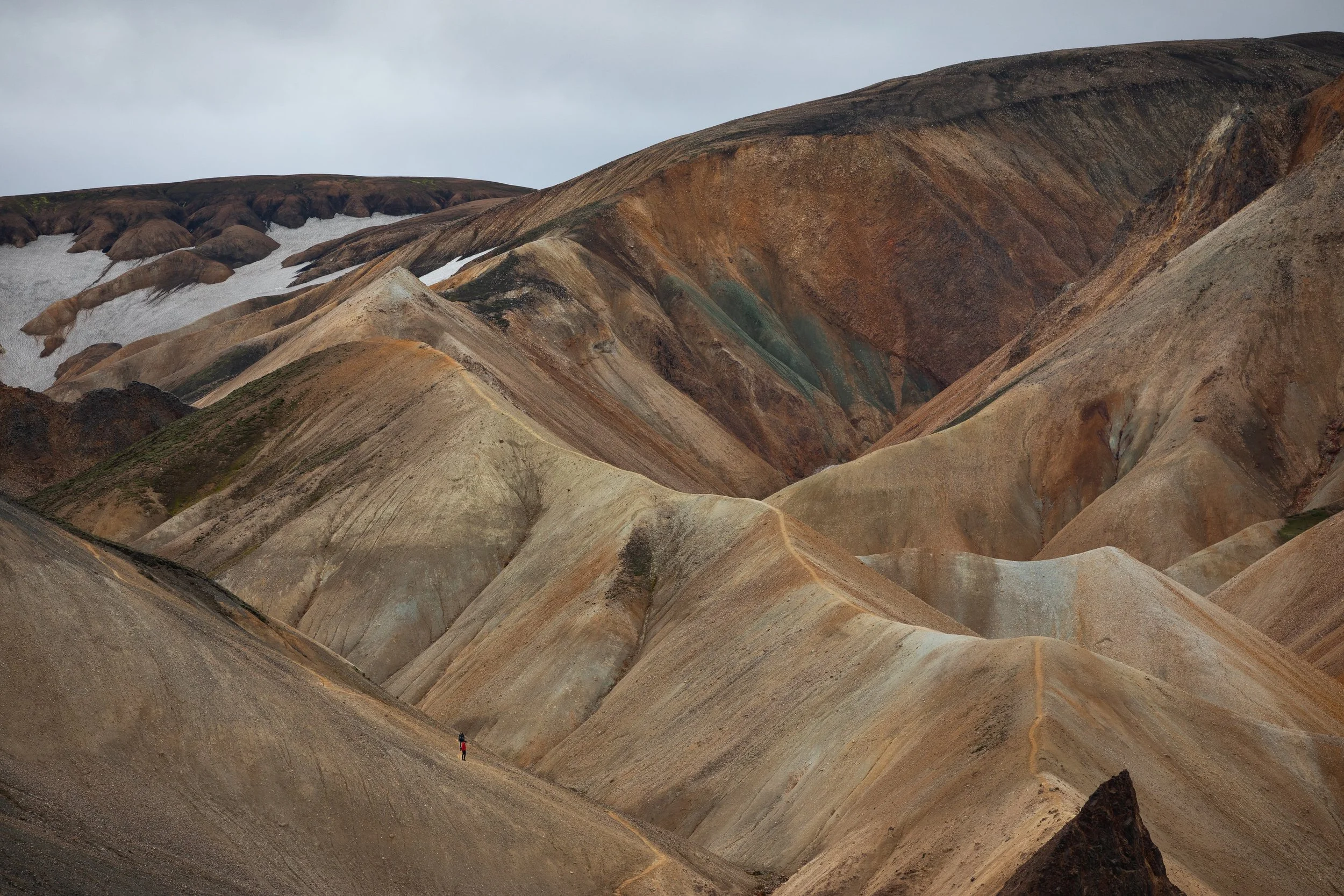
The hike to Bláhnúkur Mountain is short but steep and will make you work for the views. The trail climbs straight up to the summit without any breaks and has steep drop-offs on either side, so it is not for the faint of heart. But once you are at the top, you have breathtaking 360-degree views!
Although you can hike down the way you came, I recommend continuing to the back side of the mountain and hiking towards the Laugahraun Loop. This descent is more gradual, making it easier on the legs. Once at the bottom of the valley floor, the trail crosses a river that is a bit deep. Many hikers take off their boots and socks for the river crossing to not have to deal with wet feet on the hike down, but we certainly saw many others crossing it without taking them off.
After the river crossing, the trail turns right to go through the geothermal area and continues on the right half of the Laugahraun Loop.
If you are up for a challenging hike in Landmannalaugar, you will love Bláhnúkur Mountain!

Mount Brennisteinsalda (Sulphur Wave)
Length: 4.1 miles
Elevation Gain: 1,000 feet
Difficulty: Moderate
Brennisteinsalda has some of the best views in Landmannalaugar and is a little bit of an easier hike than Bláhnúkur. There are a few ways to hike to Brennisteinsalda, and the route listed on AllTrails is a bit confusing. I recommend hiking the loop clockwise, and I will provide step-by-step instructions on how to follow this loop.
The 4.1-mile loop begins at the information center and follows the Laugahraun Loop behind the Mountain Mall and past the horse area before turning right into the lava field. This section of the trail is sometimes difficult to follow, but just keep an eye on the trail markers, and you will be okay.
Once the trail exits the lava field and enters the geothermal area, it comes to a trail junction with plenty of signage to help you navigate. The loop to Brennisteinsalda continues straight and becomes steep as it approaches the summit. This section is the steepest part of the loop, but the effort is worth it for the stunning 360-degree views on the summit of Brennisteinsalda.
Although you can descend the way you came, I recommend continuing around the right side of Brennisteinsalda to enjoy a more gradual descent and stunning views of the surrounding mountains. The trail then travels around the base of Brennisteinsalda along a beautiful field before connecting with the right half of the Laugahraun Loop, continuing to the information center.
Brennisteinsalda is easily one of the most beautiful hikes in Landmannalaugar, and you will quickly fall in love with the trail!

Bláhnúkur and Brennisteinsalda Loop
Length: 6.8 miles
Elevation Gain: 2,200 feet
Difficulty: Difficult
If you want to experience everything Landmannalaugar offers, this big loop is perfect for you! This 6.8-mile loop hikes to Bláhnúkur and Brennisteinsalda, making it the perfect day hike to explore the most beautiful sections of Landmannalaugar.
The loop begins at the information center and travels behind the Mountain Mall and past the horse area towards Bláhnúkur Mountain. At the first trail junction, follow the signs towards Bláhnúkur and begin the steep ascent to the summit. This section is the steepest part of the hike, so it is nice to ascend it.
The trail travels along the back side of Bláhnúkur before crossing a river and continuing towards the geothermal area. At the geothermal area, the trail continues left towards Brennisteinsalda. This section is steep, but the views at the summit are worth it!
Once on Brennisteinsalda, the trail continues over the summit and descends on the right side of the mountain. Once at the valley floor, the trail continues to the right along the edge of a beautiful field before connecting with the right half of the Laugahraun Loop.
The Bláhnúkur and Brennisteinsalda Loop is one of the most beautiful hikes in Landmannalaugar and the perfect day hike to experience everything the area offers!

Landmannalaugar to Þórsmörk (Multi-Day Hike)
Length: 32.4 miles
Elevation Gain: 5,600 feet
Difficulty: Very Difficult
The Landmannalaugar to Þórsmörk hike is one of the most breathtaking hikes in Iceland. It is a 32.4-mile point-to-point hike starting in Landmannalaugar and ending in the beautiful Þórsmörk. This trail is typically hiked in 4-5 days as a backpacking trip, and only experienced backpackers should hike it. You can also hike it with a tour group!
The hike travels over some of the most beautiful areas in the highlands of Iceland, and the views will take your breath away. Although it is stunning, it is not easy. The weather in the highlands makes this hike difficult, so you must have the appropriate gear to prepare for anything the weather can throw at you.
If you end up hiking from Landmannalaugar to Þórsmörk, you will not be disappointed! And you will quickly realize why it is one of the best hikes in Landmannalaugar and Iceland!
If you plan a trip to Landmannalaugar, this guide is the perfect place to find a hike. It has everything you need to know about the best hikes in Landmannalaugar!

Hey, I’m Nichole!
I am the creator behind Nichole the Nomad, the home of my explorations around the world, mountain hikes, and beautiful pictures taken along the way. I have a deep passion for capturing the world in a beautiful light and sharing my experiences.
I created this blog to share my travels, show how beautiful the world is, provide tips and tricks for traveling, and encourage you to explore. Whether you want to travel across the world or explore what’s in your backyard, I hope this blog inspires you to get outside and find your adventure!
Pin it for later!