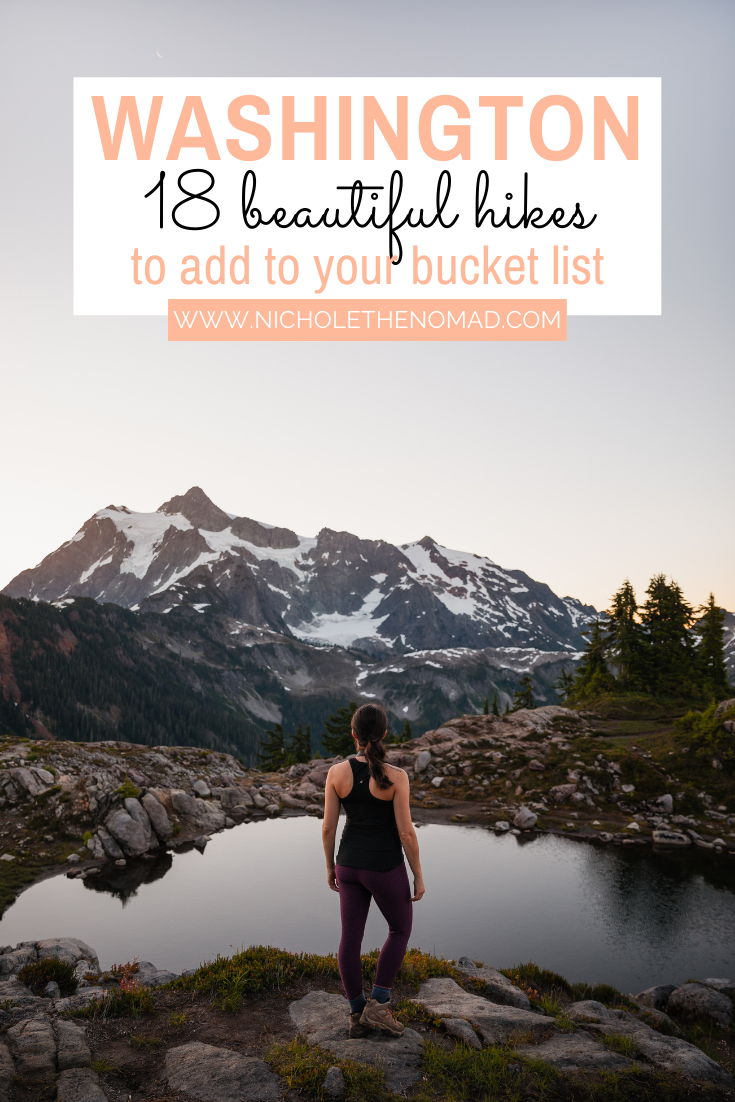
The 18 Best Hikes in Washingtons
Washington has hundreds of trails in its national parks that lead to beautiful views of mountains, waterfalls, alpine lakes, and old-growth forests. Mount Rainier National Park, Olympic National Park, and North Cascades National Park are home to some of the best hikes in Washington.
Mount Rainier National Park offers breathtaking views of Mount Rainier from almost every trail. Olympic National Park has trails leading you through rainforests, along beaches, and up mountain ridges. North Cascades National Park offers stunning views of mountains and alpine lakes.
If you hike in Washington, you will not be disappointed! This guide reviews the best hikes in Washington for every level that you need to add to your bucket list!

Disclaimer: This post contains affiliate links. If you click through and make a purchase, my blog may receive a commission at no additional cost to you.
Tips for Hiking in Washington
Trails in Washington’s national parks can have winter conditions through July, which means snow and ice can linger. It is very important to read recent trail reviews, speak with park rangers if you have questions about the trail conditions, and pack the appropriate gear.
Washington’s weather can be unpredictable, especially up in the mountains. The weather in Washington’s national parks can change quickly, so I always recommend packing layers and rain gear when hiking.
Washington’s national parks are very popular and become crowded early in the day. During peak season and on weekends, parking lots can fill up by 8:00 AM. I highly recommend arriving at trailheads early to secure a parking spot and enjoy a more peaceful hiking experience.
Mount Rainier National Park now has a timed entry reservation system for entering the park between 7 AM to 5 PM from July through September and weekends in September and October for the Sunrise Corridor . You should get these as far in advance as possible since Mount Rainier National Park is a busy park. If you do not have a permit, you can still enter the park before 7 AM and after 5 PM.
Always remember to leave no trace. It’s crucial to pack out what you pack in and leave no trash. Some of these spots have trash bins, so you can easily throw your trash away. If they don’t have trash bins, you can throw your trash away at a nearby gas station or convenience store.
What to Pack to Hike in Washington
Hiking Boots: If you want comfort and support on your trip, hiking boots are the go to.
Hiking Socks: Having moisture-wicking and comfortable hiking socks are just as important for exploring.
Hiking Backpack: You need something to carry all your food, clothes, and anything else you need while adventuring, so having a supportive hiking backpack is crucial.
Hydration Reservoir/Water Bottles: While hiking or just exploring, it is important to have enough water! I always pack a hydration reservoir.
Jackets: The weather is unpredictable, so I always pack a rain jacket and insulated jacket.
Ten Essentials: The Ten Essentials are crucial for hiking!
Best Easy Hikes in Washington
Rainy Lake
Length: 2 miles
Elevation Gain: 70 feet
Rainy Lake is a beautiful lake surrounded by mountains located in North Cascades National Park. The easy trail is paved, making it wheelchair-accessible, and is one of the most accessible hikes in the park.
Because the trail to Rainy Lake is easy and accessible, it is one of the most popular trails in North Cascades National Park. The parking lot fills up quickly and can be full by 9:00 AM. I highly recommend arriving at the Rainy Pass trailhead early, so you can secure a parking spot and enjoy the beautiful lake in peace.
Hall of Mosses

Length: 0.8 miles
Elevation Gain: 100 feet
Hall of Mosses is an iconic trail located in the Hoh Rain Forest in Olympic National Park. The beautiful and short trail begins in the Hoh Rainforest Visitor Center parking lot and leads through one of Washington’s most beautiful and lush rainforests.
Hiking to the Hall of Mosses will make you feel like you have been transported to a different part of the world with huge moss-draped trees. The Hoh Rainforest is one of the most popular areas in Olympic National Park, so I highly recommend arriving at the trailhead early. If the parking lot is overflowing with traffic, the Olympic National Park staff will stop traffic going to Hoh Rainforest.
I highly recommend hiking to the Hall of Mosses during the early morning or late afternoon hours. Golden hour in the Hall of Mosses is so beautiful!
Hole-in-the-Wall at Rialto Beach

Length: 4 miles
Elevation Gain: minimal
Want to have a scenic stroll on a beautiful beach? The Hole-in-the-Wall is a beautiful rock formation on Rialto Beach in Olympic National Park. The hike to Hole-in-the-Wall begins in the Rialto Beach parking lot and follows north on the beach.
The easy hike brings you along the shores with waves crashing over large sea stacks. After a mile, the trail passes through Ellen Creek, which may require you to get your feet wet, depending on the water levels. As you continue north on Rialto Beach, you will soon see the Hole-in-the-Wall in the distance.
If it is low tide, you can go into the Hole-in-the-Wall to get the classic photo or explore the tide pools next to it. I highly recommend hiking to the Hole-in-the-Wall during sunset to watch the sun kiss the sea as it sets for the day.
It is very important to check the tide schedule before hiking to the Hole-in-the-Wall. When it is high tide, the tide can come up to the large pieces of driftwood on Rialto Beach, making it almost impossible to hike.
Marymere Falls
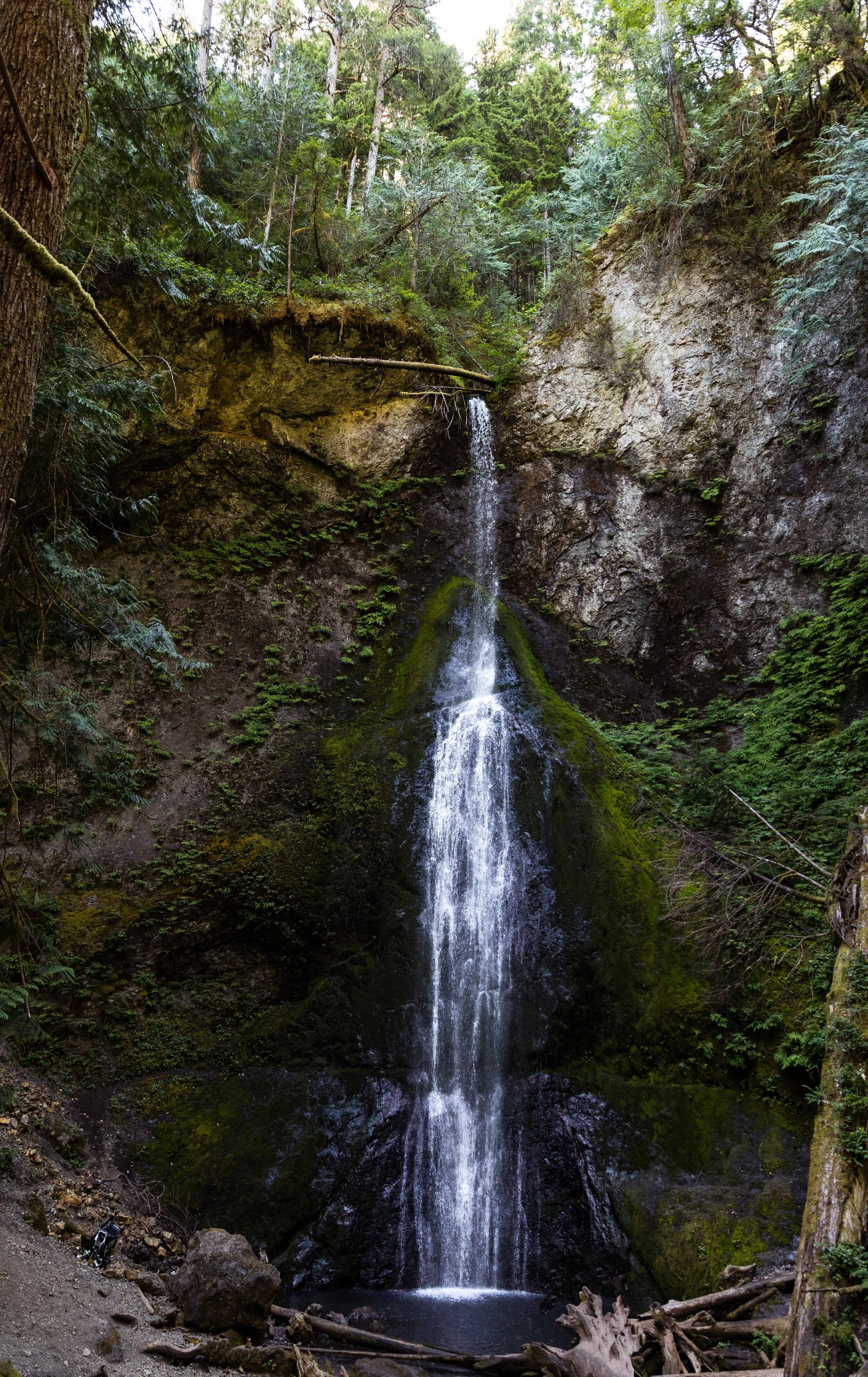
Length: 1.8 miles
Elevation Gain: 500 feet
Marymere Falls is a beautiful 90-foot waterfall in Olympic National Park near the shores of Lake Crescent and is one of the most beautiful waterfalls in Washington, in my opinion.
The easy hike begins at the Storm King Ranger Station and follows along a paved path for a half-mile. The trail will come to a junction, where it continues left through an old-growth forest towards Marymere Falls. Before the waterfall, the trail forms a loop, leading to two viewpoints.
The upper viewpoint allows you to look down on Marymere Falls, and the lower viewpoint allows you to view the waterfall near its base. In my opinion, the lower viewpoint is a better spot to view Marymere Falls.
Once you complete the hike to Marymere Falls, I highly recommend spending some time on the shores of Lake Crescent and taking a dip into the beautiful lake!
Grove of the Patriarchs

Length: 1.5 miles
Elevation Gain: 50 feet
NOTE: Currently closed due to trail damage. Read more here.
Grove of the Patriarchs is one of the easiest trails in Mount Rainier National Park and is great for all ages. The trail to Grove of the Patriarchs begins in the first parking lot on Stevens Canyon Road and follows along the Ohanapecosh River before coming to a suspension bridge.
The trail continues over the bridge and under huge cedars, Douglas-first, and hemlocks. Some of the trees along the Grove of the Patriarchs are over 300 feet tall and 40 feet wide! The Grove of the Patriarchs is sure to leave you feeling tiny in a good way.
The parking lot for the Grove of the Patriarchs is very small, so I recommend arriving here early because this is a very popular hike.
Alta Vista Trail

Length: 1.5 miles
Elevation Gain: 560 feet
The Alta Vista Trail is a beautiful trail located in the Paradise section in Mount Rainier National Park. The easy trail begins in the upper or lower lot in Paradise and follows along a paved path for most of the trail.
The Alta Vista Trail follows along wildflower meadows and provides incredible views of Mount Rainier. There are many trails off of the Alta Vista Trail, so it’s important to follow the signs to make sure you are on the correct trail. If you are looking to extend your hike, there are plenty of trails to choose from!
Best Moderate Hikes in Washington
Blue Lake
Length: 4.4 miles
Elevation Gain: 1,050 feet
Blue Lake is a beautiful alpine surrounded by mountains located in North Cascades National Park. The hike begins at the Blue Lake Trailhead parking lot off of Highway 20 and starts descending to one of many small boardwalks along the trail. The trail throws you into a beautiful meadow of wildflowers until you pass over a small creek and head back into the trees.
As you approach the end of the last section of the trail, you are rewarded with incredible mountain views! Soon enough, you will see Blue Lake just over a log bridge. Blue Lake may look like a great place to swim, but the waters are ice cold year-round.
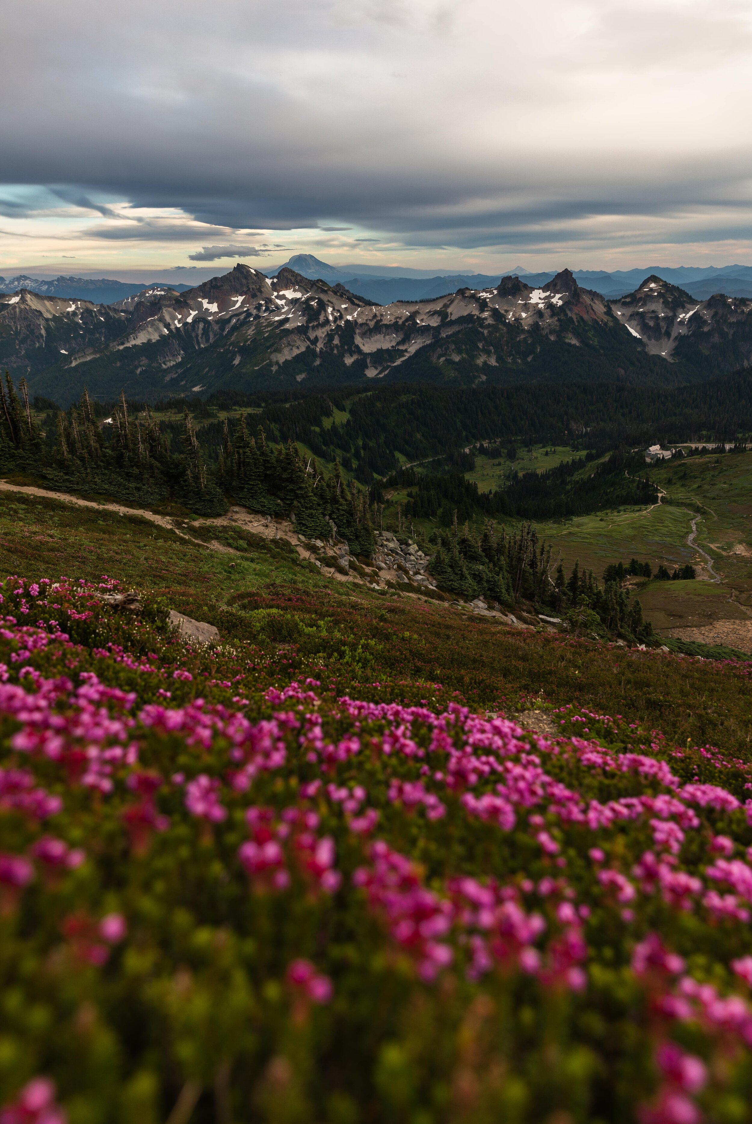
Table Mountain

Length: 2.6 miles
Elevation Gain: 725 feet
Table Mountain is a great hike located in North Cascades National Park. The trail begins at the Artist Point parking lot off of the Mount Baker Highway and immediately begins to ascend on switchbacks. The switchbacks are very steep and rocky, so I do not recommend hiking to Table Mountain if the trail is wet.
After the switchbacks, the trail follows along the ridge for another mile before reaching the viewpoint on Table Mountain. Table Mountain offers beautiful views of Mount Baker, Mount Shuksan, and other surrounding mountains.
We hiked to Table Mountain for sunset, and it was beautiful! The hike has endless views along the entire hike.
Chain Lakes Loop

Length: 6.5 miles
Elevation Gain: 1,820 feet
Chain Lakes Loop is a beautiful hike located in North Cascades National Park that offers views of Mount Baker, Mount Shuksan, and multiple lakes and is considered one of the best hikes in Washington! There are three ways to begin the Chain Lakes Loop, with the most common being Artist Point.
From the Artist Point parking lot, the trail follows down a short path, crosses over the overflow parking lot, and follows the Wild Goose Trail to the Austin Pass parking lot. From the parking lot, the trail continues across the lot and past an interpretive sign.
The Chain Lakes Loop will bring you past the beautiful Bagley Lakes before heading to Herman Saddle. Herman Saddle is the highest point on the Chain Lakes Loop and provides some of the best views on the hike. Once you descend from Herman Saddle, you will come to a trail junction where Chain Lakes Loop continues straight and to the left towards Iceberg Lake and Mazama Lakes. The trail then begins to climb back up and ends at Artist Point.
Chain Lakes Loop offers incredible views along the entire trail and is worth the few steep sections you have to tackle.
Hurricane Hill

Length: 3.2 miles
Elevation Gain: 650 feet
Hurricane Hill is an incredible hike near Hurricane Ridge in Olympic National Park. The trail to Hurricane Hill begins from multiple areas near the Hurricane Ridge Visitors Center and follows along an easy-to-follow trail.
The first section of the trail has interpretive signs pointing to nearby burns, towns, and mountains. The trail will continue on switchbacks and gradually bring you up to the top of Hurricane Hill, where you can see Port Angeles, Vancouver Island, and the Bailey Range.
The Hurricane Ridge parking lot is a very popular spot for sunset, so if you are looking for a more peaceful place, Hurricane Hill is perfect!
Naches Peak Loop

Length: 3.2 miles
Elevation Gain: 600 feet
Naches Peak Loop is located near Tipsoo Lake in Mount Rainier National Park. I recommend hiking Naches Peak Loop clockwise, so you end with beautiful views of Mount Rainier. The trail begins at Tipsoo Lake and follows along the Pacific Crest Trail at the base of Naches Peak.
You will be surrounded by an endless amount of wildflowers if hiking in late July and early August. The smells of the magenta paintbrush and blue lupine fill the air as you loop around to the other side of Naches Peak.
You will soon come to a trail junction where the Pacific Crest Trail continues left, and Naches Peak Loop continues right. Once around Naches Peak, you are rewarded with stunning views of Mount Rainier. Naches Peak loop continues into the trees and ends back in the Tipsoo Lake parking lot.
Naches Peak Loop is a fan favorite among visitors, so I recommend arriving at Tipsoo Lake parking lot early before it fills up!
Fremont Lookout

Length: 5.6 miles
Elevation Gain: 1,200 feet
Fremont Lookout is one of my favorite hikes in Mount Rainier National Park and is considered one of the best hikes in Washington! The trail to Fremont Lookout begins at the Sunrise Visitor Center parking lot and follows along the Sourdough Ridge Trail to the Frozen Lake junction.
The trail continues right around Frozen Lake and ascends steeply to the ridge where Fremont Lookout stands. Once you get to the top of the steep section, the trail wraps around, and you will see Fremont Lookout in the distance. Once you arrive at Fremont Lookout, you are rewarded with incredible views of Mount Rainier, Skyscraper Peak, Redstone Peak, and Grand Park.
If you have a headlamp and are comfortable hiking in the dark, I highly recommend hiking to Fremont Lookout for sunrise or sunset.
Tolmie Peak Lookout
Length: 7.5 miles
Elevation Gain: 1,100 feet
NOTE: The State Route 165 Carbon River Fairfax Bridge is closed until further notice, making this area currently inaccessible. For the latest updates, please visit WSDOT’s website.
Tolmie Peak Lookout is one of four remaining historic fire towers in Mount Rainier National Park. The Tolmie Peak Trail begins at the Mowich campground parking lot and follows along the shores of Mowich Lake, which is the largest lake in Mount Rainier National Park.
The trail begins to ascend toward Ipsut Pass steeply before arriving at Eunice Lake. The Tolmie Pass Trail has one final and steep push for a mile to the lookout that will reward you with stunning views of Mount Rainier.
Tolmie Peak Lookout is not open for overnight camping, so if you want to hike this for sunrise or sunset, it has to be done as a day hike.
Best Difficult Hikes in Washington
Heather-Maple Pass

Length: 7.2 miles
Elevation Gain: 2,000 feet
Heather-Maple Pass is one of my favorite hikes in North Cascades National Park and is considered one of the best hikes in Washington. This hike will leave you speechless with its mountain views, blue lakes, and endless wildflowers.
The Heather-Maple Pass Loop begins in the Rainy Pass parking lot and is usually hiked counter-clockwise, heading up towards Heather Pass first. The trail immediately begins to ascend gradually for one mile before coming to a junction with the trail to Lake Ann.
If you want to add Lake Ann to your hike, the trail is an easy 0.6 miles to a bright blue lake. Continuing on the Heather-Maple Pass Loop, the trail begins to climb through meadows of wildflowers for another mile before reaching Heather Pass.
After taking in the beautiful views at Heather Pass, the trail continues on the Heather-Maple Pass Loop towards Maple Pass. The trail follows along a ridge, providing incredible panoramic views of many mountains, including Black Peak, Stiletto Peak, Frisco Mountain, and Goode Mountain. This area is the perfect place to take a snack break while taking in the endless views before heading back down.
The Heather-Maple Pass Loop begins to descend on switchbacks before entering the treeline. As you approach the parking lot, the trail connects with the Rainy Lake trail, which is paved. If you want to add Rainy Lake to your hike, it is an easy 0.5 miles to the beautiful lake.
I loved Heather-Maple Pass but wished we hiked it for sunrise!
Cascade Pass and Sahale Arm
Length: 12 miles
Elevation Gain: 4,000 feet
The hike to Cascade Pass and Sahale Arm is said to be one of the most beautiful and rewarding hikes in North Cascades National Park. The Cascade Pass Trail begins at the end of Cascade River Road and immediately begins to ascend steeply up seemingly endless switchbacks.
As soon as you think the constant uphill will never end, the trail leads you to Cascade Pass, offering incredible views of Sahale Mountain and its glacier. The next portion of the trail switches back and forth from flat to steep to ridges and through trees before reaching the Sahale Glacier Camp. The views from here are endless! You can see some of the tallest mountains in North Cascades National Park.
Although this is a strenuous hike, the views make the climb worth it!
Burroughs Mountain

Length: 9 miles
Elevation Gain: 2,500 feet
Burroughs Mountain brings you the closest to Mount Rainier you can get in the Sunrise section of Mount Rainier National Park. It is known as the mountain against a mountain.
The trail to Burroughs Mountain begins at the Sunrise Visitor Center parking lot and follows along the Sourdough Ridge Trail to the Frozen Lake junction. The Burroughs Mountain Trail turns left and begins to ascend steeply to First Burroughs.
The trail then continues to climb from First Burroughs to Second Burroughs, providing incredible views of Mount Rainier along the entire trail. Although the views from Second Burroughs are stunning, I highly recommend continuing three miles to Third Burroughs.
If you decide to tackle the rest of the hike, you will add over 1,000 feet of elevation to your hike, but I promise it is worth it! Third Burroughs provides an up-close and personal experience with Winthrop Glacier on Mount Rainier. It is incredible!
If you hike to Burroughs Mountain midday, remember to pack sunscreen! There is little to no shade along the trail.
Skyline Trail
Length: 6 miles
Elevation Gain: 1,450
The Skyline Trail is my favorite hike in the Paradise section of Mount Rainier National Park and is considered one of the best hikes in Washington. The trail begins at the Jackson Visitor Center parking lot and immediately plops you in a large trail system maze. Paradise has many trails, so I highly recommend grabbing a map from the visitor center before beginning the hike.
The Skyline Trail immediately begins to ascend steeply through meadows of wildflowers. After the trail begins to flatten, it will bring you past Glacier Vista. I highly recommend stopping at Glacier Vista to take in the incredible views of Mount Rainier. Glacier Vista offers the best views of Mount Rainier on the Skyline Trail.
After Glacier Vista, the Skyline Trail hikes along Nisqually Glacier and loops around toward Panorama Point. The trail comes to a junction where hikers planning to summit Mount Rainier will take to head to Camp Muir, but you will continue straight to stay on Skyline Trail. Panorama Point offers incredible views looking south towards Mount Adams and Mount St. Helens. On clear days, you can see Mount Hood, too!
From Panorama Point, the Skyline Trail climbs a short distance before leveling off next to Mount Rainier and descending the ridge. The trail then comes to the Golden Gate Trail junction, which offers a shorter way to get back to the parking lot. Whether you decide to descend on the Skyline Trail or Golden Gate Trail, you will hike past beautiful waterfalls before arriving back at the parking lot.
I loved the Skyline Trail, and I highly recommend it to everyone up for a great hike with incredible views!
Wonderland Trail

Length: 93 miles
Elevation Gain: 22,000 feet
The Wonderland Trail is arguably the best hike in Washington and the best way to experience all of what Mount Rainier National Park has to offer. The 93-mile trail is known as one of the most beautiful but strenuous trails in Washington.
Permits for the Wonderful Trail are highly sought after, and only a handful of hikers each year score them. If you score a permit, you will embark on an incredible journey through lowland forests and meadows of wildflowers and have incredible views of Mount Rainier.
Note: Winter conditions on the Wonderful Trail can last through June, and the weather can change quickly, so it is crucial to be prepared and have the appropriate gear.
If you want the full information on the Wonderland Trail, please visit the NPS website.
This guide is a great place to start adding the best hikes in Washington to your Washington bucket list! Make sure to check out my helpful guides for Mount Rainier National Park, Olympic National Park, and North Cascades National Park for must-see sights, where to stay, and more of the best hikes in Washington!

Hey, I’m Nichole!
I am the creator behind Nichole the Nomad, the home of my explorations around the world, mountain hikes, and beautiful pictures taken along the way. I have a deep passion for capturing the world in a beautiful light and sharing my experiences.
I created this blog to share my travels, show how beautiful the world is, provide tips and tricks for traveling, and encourage you to explore. Whether you want to travel across the world or explore what’s in your backyard, I hope this blog inspires you to get outside and find your adventure!
Pin it for later!