Mount Shaw NH via Cold Spring Trail
Disclaimer: This post contains affiliate links. If you click through and make a purchase, my blog may receive a commission at no additional cost to you.
Mount Shaw NH Hike Overview
Mount Shaw (2,990’) is in the Lakes Region in New Hampshire and is the tallest mountain in the Ossipee Range. It is one of many mountains in the Castle in the Clouds trail network but has the best views, in my opinion, landing it on the 52 With a View List. The views from the summit overlooking the White Mountains are stunning, and on a clear day, you can see Franconia Ridge, Mount Washington, and into Maine.
Trail Details
Trail: Cold Spring Trail > Fairway Mountain Connector > Oak Ridge Cutoff > High Ridge Trail
Length: 7.5 miles
Elevation Gain: 1,800 feet
My Trail Time: 3 hours hiking; 3.5 hours total
Hike Overview
Although Mount Shaw has many trails leading to its summit, we decided to hike a lesser-hiked route since we hiked in the winter. Many people hike to Mount Shaw via the Mount Shaw trail, but we hiked it via the Cold Spring Trail.
A section of the Cold Spring Trail is a snowmobile trail. In the winter, you must use caution when hiking along this section and be on the lookout for snowmobilers. The Castle in the Clouds also has many trails in its system, making it crucial to pay attention to the signs to stay on the right path.
Looking to track your hikes while completing the 52 With a View List?
Whether you're chasing stunning summit views or documenting your adventures, this journal helps you track essential hike details, jot down memories, and reflect on your journey!
Each journal includes:
- individual pages for each mountain
- space to log stats about the hike
- sections to journal about your favorite moments
- completion tracker to celebrate your progress
- and fun extras like Hiking Bingo!

Mount Shaw NH via Cold Spring Trail Guide
February 15, 2024
**Always remember to leave no trace. It is crucial to pack out what you pack in and throw away your trash properly.
I had my eye on hiking Mount Shaw since it is one of the easy hikes on the 52 With a View List I have left. I had heard mixed opinions on Mount Shaw, but many people said it was nothing special, so I was not expecting much with its views. I learned quickly that whoever said the views were not spectacular was wrong!
Mount Shaw has two popular routes - one from the Castle in the Clouds area via Cold Spring Trail and the other from Route 171 via Mount Shaw Trail. Both have similar mileage and elevation gain, but we decided to hike it from Cold Spring Trail because it is a more popular winter route.
We hiked Mount Shaw on a stunning Thursday in February. We were supposed to hike to the higher summits, but the wind chill was around -40 degrees, so we opted for a lower peak on the 52 With a View List.
We began the hike to Mount Shaw walking on Cold Spring Road, which had very little snow, before turning right onto Cold Spring Trail. The Castle in the Clouds area has a large network of trails, but their signage is always great! We had no problem following our desired path without getting lost.
Soon after turning onto Cold Spring Trail, we turned right onto the Fairway Mount Connector Trail and then onto Oak Ridge Cutoff soon after. The elevation gain was very gradual, and the snow was packed down nicely, so we only needed microspikes for our hike.
Oak Ridge Cutoff steadily gained elevation before we turned right to continue on Oak Ridge Trail. The first mile of Oak Ridge Trail was pretty flat, which was a nice break before we began the final climb to Mount Shaw. Even though the snow was packed down nicely, we noticed there was not much snow left on the trail, which was crazy since it was only February!
Most of Oak Ridge Trail is a snowmobile trail, which was great since the trail was in great shape. We did not come across any snowmobilers because the trails were closed since the bottom of them does not have any snow. But Oak Ridge Trail had a few sharp corners that would have made it difficult for snowmobilers to see hikers. If you hike this in the winter, keep that in mind!
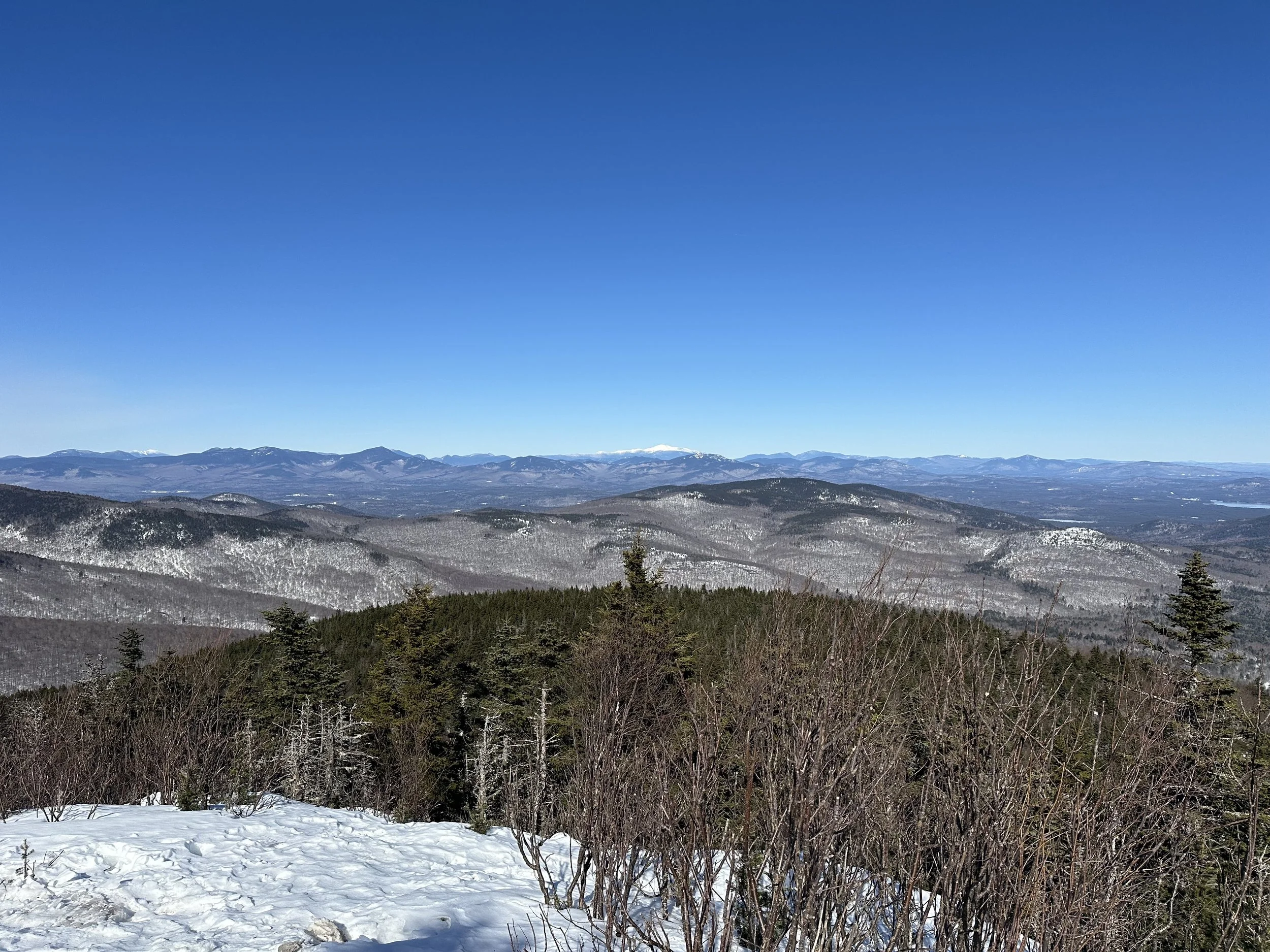
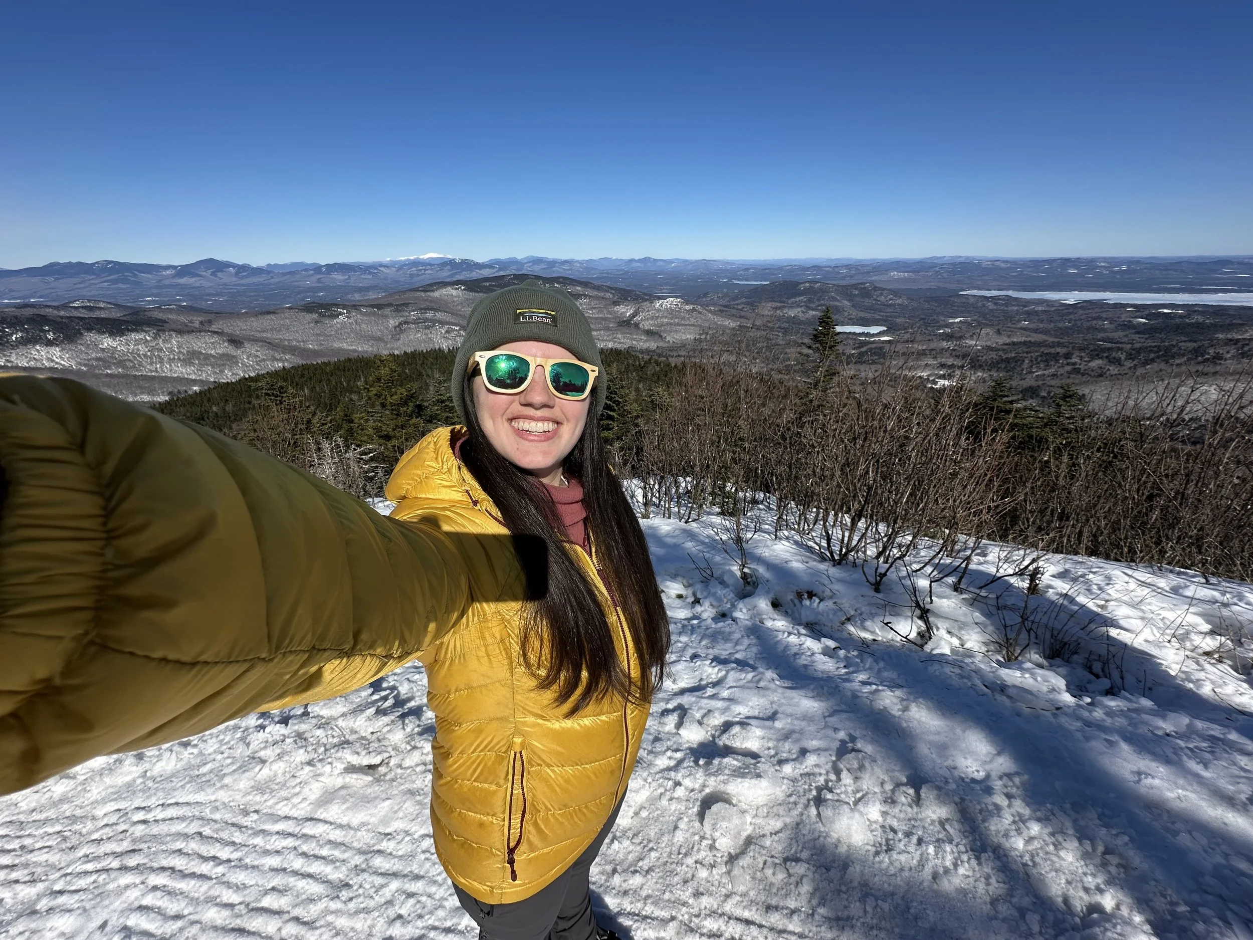
The final mile of Oak Ridge Trail became steeper as we approached Mount Shaw, but it never became too strenuous. The summit had a small loop, and the best views were on the northern side of it. As I mentioned, many people told me the views were not the best, so I was not expecting much, but let me tell you… the views were spectacular! We lucked out having a bluebird day, allowing us to see for miles into the White Mountains and Maine. We could make out Franconia Ridge, the Presidential Range, and some parts of Maine.
We stayed at the summit for about a half hour, enjoying the stunning views before the wind began to pick up. The clouds were quickly making their way in, so we decided to start our descent.
The descent flew by, and we did not pass a single person. Before we knew it, we were back on Cold Spring Road and walking back to our cars.
Mount Shaw is honestly one of my new favorite winter hikes! It was not overly strenuous, even though it was longer than others. And the views were breathtaking!
Have you hiked Mount Shaw?

Hey, I’m Nichole!
I am the creator behind Nichole the Nomad, the home of my explorations around the world, mountain hikes, and beautiful pictures taken along the way. I have a deep passion for capturing the world in a beautiful light and sharing my experiences.
I created this blog to share my travels, show how beautiful the world is, provide tips and tricks for traveling, and encourage you to explore. Whether you want to travel across the world or explore what’s in your backyard, I hope this blog inspires you to get outside and find your adventure!