The 9 Best Hikes Near Vik, Iceland: Hiking Near Vik
Vik is a cute fishing town along the south coast of Iceland and is one of the most popular areas. Since it is near many iconic waterfalls, black sand beaches, and other attractions, Vik is one of the best places to visit in Iceland!
Although you can see many must-see attractions from overlooks, one of the best ways to experience everything Vik offers is by hiking its trails! Vik has many beautiful hiking trails nearby that will leave you in awe. Whether you want to hike to a waterfall, cliff, or mountain, Vik has a hiking trail for everyone. This guide has everything you need to know about hiking near Vik and the best trails to add to your bucket list!

Disclaimer: This post contains affiliate links. If you click through and make a purchase, my blog may receive a commission at no additional cost to you.
Tips for Hiking Near Vik
Most trails near Vik require a parking fee. Some trailheads have kiosks, while others use an app called Parka. I recommend downloading it in advance and inputting your car information so it is easy to pay once you arrive at the trailhead.
Get a map of the hiking trails. Although most of the hikes near Vik are well-marked, it is crucial to have a map just in case.
Arrive early. Many trails near Vik are popular, and there are always crowds. I recommend visiting early in the morning or later in the afternoon to avoid the mid-day crowds. If you visit during the midnight sun, you can hike near midnight when there are almost no crowds!
Be flexible. There may be times when parking lots are full, so I recommend leaving room in your itinerary to make last-minute changes. You can always go back to the hiking trails at different times!
Always remember to leave no trace. It’s crucial to pack out what you pack in and leave no trash. Some of these spots have trash bins, so you can easily throw your trash away. If they don’t have trash bins, you can throw your trash away at a nearby gas station or convenience store.
What to Pack for Hiking Near Vik
Iceland weather can be unpredictable, so it is crucial to pack the right gear and layers for the season you visit. Both times we visited, the weather changed quickly and unexpectedly throughout the day!
This is a great baseline for what to pack, and you can adjust as needed:
Where to Stay Near Vik
Vik has a small downtown area with a few great places to stay during your trip! Whether you are staying for a few days or just passing by, it has everything you need, including restaurants, gas stations, and grocery stores.
Best Vik Hotels:
Map of Hikes Near Vik, Iceland
The Best Hikes Near Vik, Iceland
Reynisfjara Trail
Length: 1 mile
Elevation Gain: minimal
Difficulty: Easy
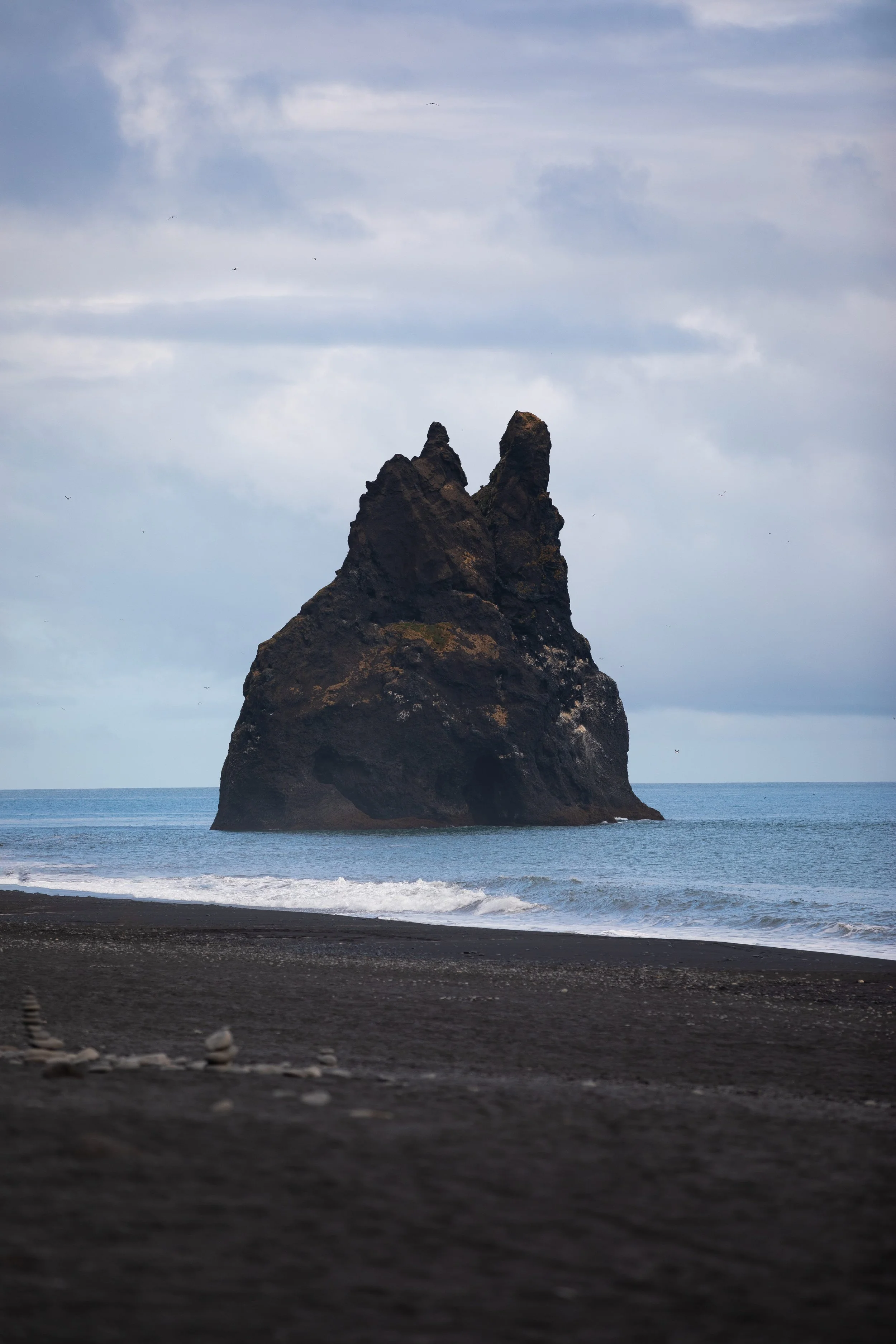
Reynisfjara is the iconic black sand beach in Vik that draws hundreds of thousands of visitors. It is stunning, with basalt columns, sea stacks, and ocean views.
Although you can see Reynisfjara from the parking lot, I highly recommend hiking the short trail along the black sand beach. The 1-mile round trip trail passes the Reynisdrangar sea stacks, the Hálsanefshellir sea cave, and the Gardar cliff. It is not marked, but you will see many people exploring the beach where the cliffs, caves, and basalt columns are. The trail is easy and a great way to explore the iconic black sand beach in Vik!
Note: The waves along Reynisfjara are known to be crazy. Reynisfjara is known for its sneaker waves, which can appear out of nowhere and sweep you off your feet. It is crucial to pay attention while you are exploring Reynisfjara!
Reynisfjall Mountain Trail
Length: 4 miles
Elevation Gain: 1,300 feet
Difficulty: Moderate/Strenuous
If you want to skip the crowded beach and experience it from a higher viewpoint, look no further! Reynisfjall Mountain sits on Reynisfjara and provides some of the best views in Vik!
The 4-mile trail follows a gravel road to the top of Reynisfjall Mountain. The first mile of the trail gains the most elevation before gradually descending to the viewpoint on Reynisfjall Mountain. The views from the mountain are unmatched, overlooking the black sand beach, sea stacks, and surrounding mountains. They will take your breath away and make the effort worthwhile!
Note: Although the map shows this hike as a loop, I recommend only hiking on the gravel road because it is much easier to follow.
Kirkjufjara Beach to Dyrhólaey Hike
Length: 2.8 miles
Elevation Gain: 800 feet
Difficulty: Moderate
If you want to avoid the crowds at Reynisfjara and explore a beautiful cliff, the hike from Kirkjufjara Beach to Dyrhólaey is perfect! Kirkjufjara Beach is a black sand beach connected to the west side of Reynisfjara and is just as stunning. It also has fewer crowds since most people only visit Reynisfjara.
The 2.8-mile round trip trail begins on Kirkjufjara Beach and travels along the black sand beach towards Dyrhólaey. Dyrhólaey is a 390-foot arch with a lighthouse and expansive views of the surrounding black sand beach and mountains. The trail climbs steeply to the top of Dyrhólaey, but the effort is worth it once you see the views! You can also drive to the top of the cliffs, but the trail is a fun way to experience the area, and you will quickly fall in love with this hike near Vik!


Sólheimasandur Plane Wreck Trail
Length: 4.6 miles
Elevation Gain: 330 feet
Difficulty: Moderate
The Sólheimasandur Plane Wreck Trail is one of the most well-known hikes near Vik because it leads to a plane wreck. In 1973, an airplane ran out of gas and crashed on this black sand beach, but everyone on board survived. Now, the plane sits on the beach, where everyone can visit.
The 4.6-mile round trip trail begins off the Ring Road and travels along the black sand beach to the Sólheimasandur Plane Wreck. To be honest, it is not one of my favorite hikes. The plane wreck is cool to explore, but Vik has better hiking trails, in my opinion. But if you want to see the Sólheimasandur Plane Wreck, this trail is the only way to get to it!
Skógafoss to Skálabrekkufoss Hike
Length: 4.1
Elevation Gain: 1,100 feet
Difficulty: Moderate
Skógafoss is one of the most well-known waterfalls in Iceland and is only a short drive from Vik. You can walk to the bottom of the 82-foot wide and 200-foot tall waterfall or hike up 530 steps to the top. Most people stop their adventure there, but there is a beautiful hike if you continue past Skógafoss!
The 4.1-mile round trip trail follows along the river above Skógafoss to multiple waterfalls. Although the waterfalls are not as epic as Skógafoss, they are beautiful! At the end, the trail leads you to Skálabrekkufoss, the most beautiful waterfall along the hike.
Although the trail is not super long, it will make you work for the waterfall views! It steadily gains elevation as you follow the river to Skálabrekkufoss, but the waterfalls are worth the effort. You will quickly fall in love with this beautiful hike near Vik!

Kvernufoss Trail
Length: 1 mile
Elevation Gain: 200 feet
Difficulty: Easy
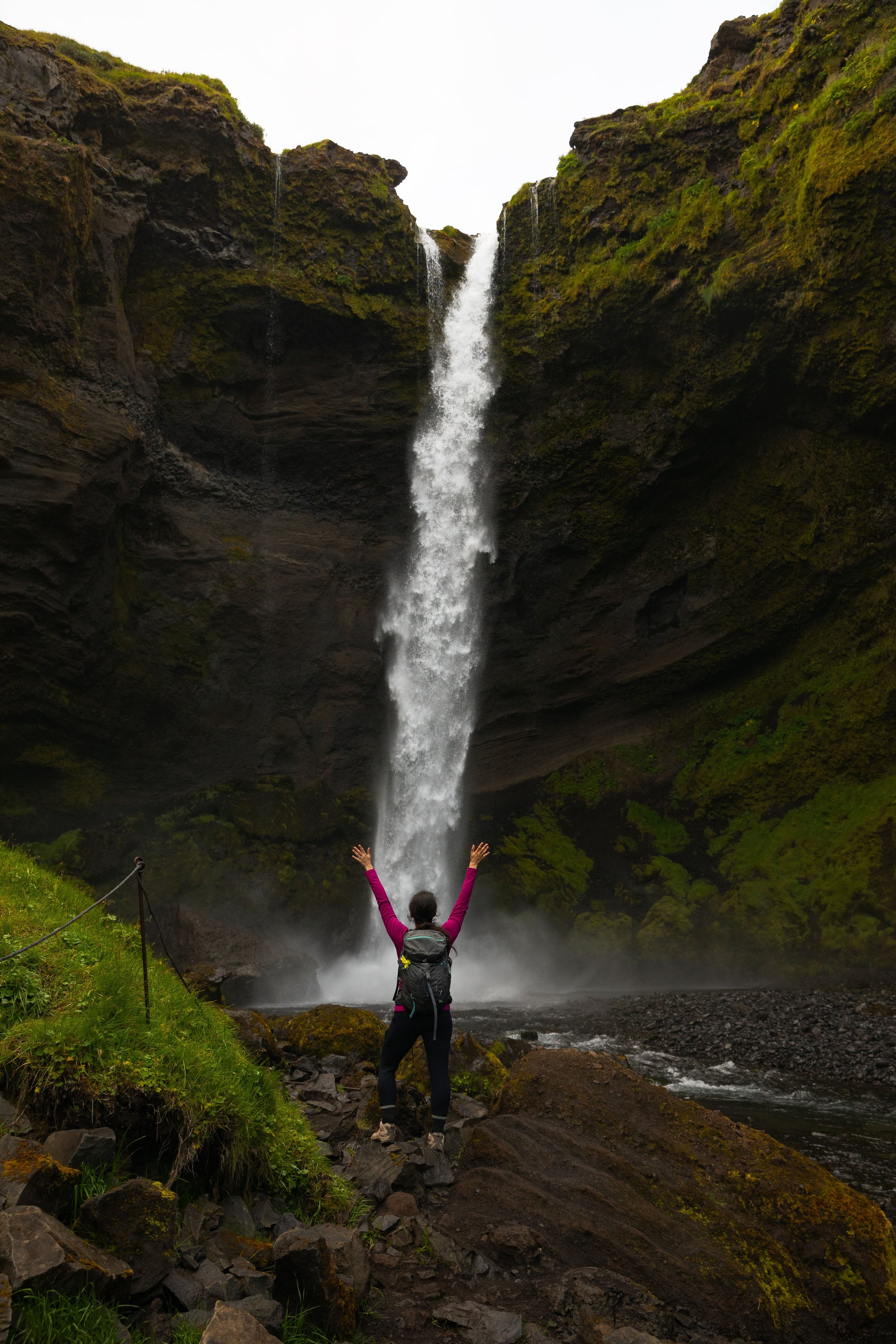
Although Kvernufoss is next to Skógafoss, many people often do not know it exists. The 98-foot waterfall is in a beautiful moss-covered canyon that will take your breath away from its beauty.
The 1-mile round trip trail to Kvernufoss is easy and worth the hike to experience this beautiful waterfall. The trail travels along a well-maintained path into the canyon and up to the bottom of the falls. It is stunning, and you will quickly understand why it is one of the best hikes near Vik!

Hjörleifshöfði Historical Promontory Trail
Length: 2.1 miles
Elevation Gain: 700 feet
Difficulty: Moderate
If you want to hike one of the most underrated trails near Vik, look no further! The Hjörleifshöfði Historical Promontory Trail is east of Vik along another black sand beach. Many people do not know this hike exists, so it is a great way to escape the crowds.
The 2.1-mile round trip trail travels along a moss-covered mountain, offering stunning views of the surrounding black sand beach, ocean, and mountains. I would go as far as to say that it has some of the best views in the area! I recommend hiking the loop clockwise to ascend the steepest section and have a gradual descent. The Hjörleifshöfði Historical Promontory Trail will quickly become one of your favorite hikes near Vik!
Sólheimajökull Overlook Trail
Length: 1.4 miles
Elevation Gain: 300 feet
Difficulty: Easy
Sólheimajökull is one of the smaller glaciers in Iceland, but it does not lack beauty! It is part of a larger glacier, Mýrdalsjökull. If you want to explore Sólheimajökull, you can take a guided hiking tour to explore crevasses and freezing water cauldrons.
But if you do not want to explore the glacier, you can hike to a viewpoint overlooking it! The 1.4-mile round trip trail follows along a gravel path to a beautiful overlook of Sólheimajökull. Although you cannot go up to the glacier due to safety reasons, you can take in the beautiful glacier from the viewpoint.
Unfortunately, the glacier is melting quickly, which you can see from various markers. But you will not be disappointed hiking to the Sólheimajökull Overlook near Vik!


Hatta Trail
Length: 3.8 miles
Elevation Gain: 1,500 feet
Difficulty: Strenuous
The Hatta Trail is one of the least-hiked trails near Vik but does not lack beautiful views! It is a great way to escape the crowds and enjoy stunning views of the moss-covered mountains and black-sand beaches.
The 3.8-mile round-trip trail is not easy and will make you work hard for the views. Although it is a lesser-known trail, the Hatta Trail is well-marked and easy to follow. The Hatta Trail begins near downtown Vik and travels steeply up a rocky path to the top without any breaks.
Once you arrive at the top, you are rewarded with some of the best views in the area, overlooking Vik and the surrounding mountains. It is easily one of the best hikes near Vik if you are up for a challenging trail!
If you want to hike during your trip to Vik, you are in the right place! This guide has everything you need to know about hiking near Vik and the best trails to add to your bucket list.

Hey, I’m Nichole!
I am the creator behind Nichole the Nomad, the home of my explorations around the world, mountain hikes, and beautiful pictures taken along the way. I have a deep passion for capturing the world in a beautiful light and sharing my experiences.
I created this blog to share my travels, show how beautiful the world is, provide tips and tricks for traveling, and encourage you to explore. Whether you want to travel across the world or explore what’s in your backyard, I hope this blog inspires you to get outside and find your adventure!
Pin it for later!

