15 Unforgettable Hikes in Death Valley
Death Valley National Park has some of the most unique landscapes in southern California, including multi-colored mountains, salt flats, sand dunes, and waterfalls. It is crazy to think the desert can have a variety of landscapes!
Although you can enjoy the views from various viewpoints in Death Valley, I recommend hiking! The trails in Death Valley give you an up-close and personal experience with the landscape and have some of the best views in the park. We spent most of our time hiking its trails, and it was worth the effort for the breathtaking views.
And the best part? Death Valley has hikes for all levels! Whether you want to enjoy a short walk to a beautiful viewpoint or a strenuous trail to a high overlook, Death Valley has a hike for everyone. This guide has everything you need to know about the best hikes in Death Valley!

Disclaimer: This post contains affiliate links. If you click through and make a purchase, my blog may receive a commission at no additional cost to you.
Tips for Hiking in Death Valley
Although you can enjoy the breathtaking views in Death Valley from the scenic drive, I recommend adding at least one hike to your itinerary. The park has trails for all levels, so no matter what type of hike you want to go on, you can find the perfect one for you.
When we visited, we spent our time hiking the easy trails, and let me tell you, they were stunning! The 360-degree views on these hikes were incredible, so I know you will love hiking in Death Valley.
Important things to Know
- Be prepared for hiking in the heat. Death Valley National Park is one of the hottest places in the world, with temperatures reaching over 110 degrees in the summer! I recommend visiting between late fall and early spring for the best temperatures. When we visited in March, it was still hot! Regardless of when you visit, you must prepare for the heat with plenty of water, food, moisture-wicking clothes, and sun protection.
- Buy the America the Beautiful Annual Pass. If you are visiting more national parks on your trip or within the year, I highly recommend buying the America the Beautiful Annual Pass. It allows you into any national park and federal recreation land for a year!
- Always remember to leave no trace. It’s crucial to pack out what you pack in and leave no trash. Some spots have trash bins, so you can easily throw your trash away. If they don’t have trash bins, you can throw your trash away at a nearby gas station or convenience store.
Trail Information
- Hike longer trails in the morning. Because Death Valley is one of the hottest places in the world, I recommend hiking in the early morning or late afternoon to avoid the midday heat. Since Death Valley receives over one million visitors a year, starting your day early in the morning allows you to hike in the park with fewer crowds, too!
- Pack sunscreen and hiking gear. Most hiking trails in Death Valley have little to no shade, making it crucial to wear sunscreen. I reapplied sunscreen multiple times during the day to be safe. You should also have hiking boots, moisture-wicking clothes, and a hiking backpack with food and plenty of water.
- Pack plenty of food and water. The nearest city with food is about a half hour, so I recommend getting everything you need for your trip before entering the park. Make sure to pack more water than you think you will need to stay hydrated while hiking.

The Best Hikes in Death Valley
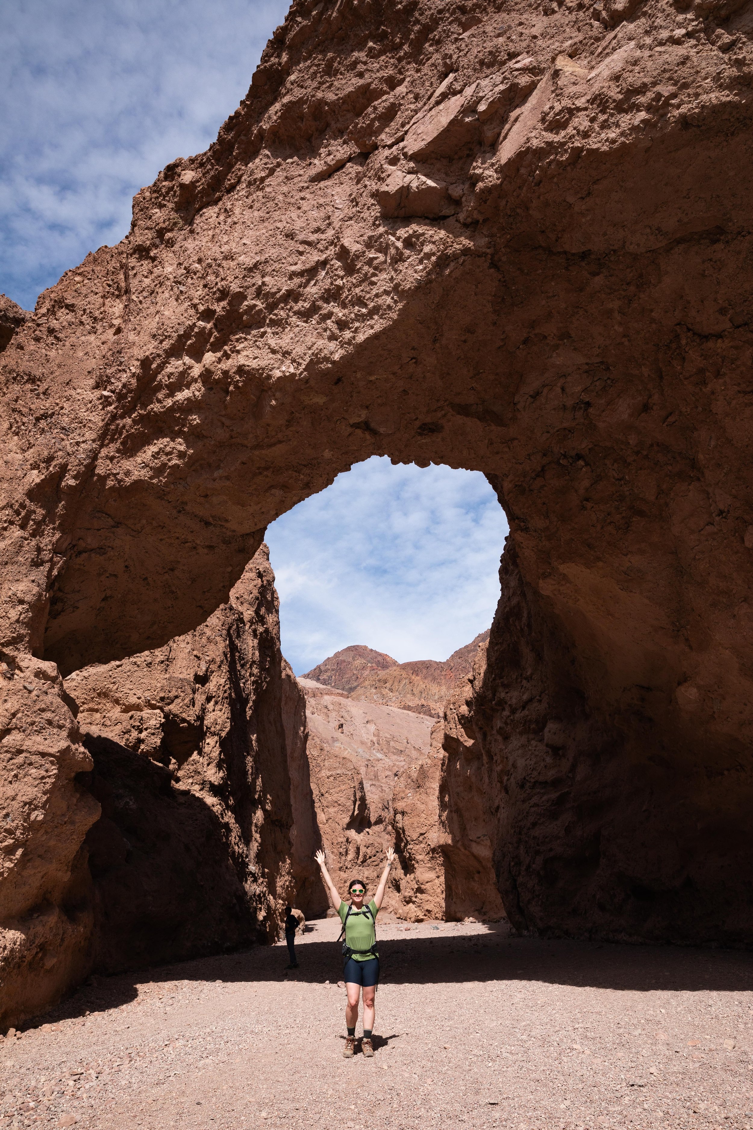
Natural Bridge Canyon Trail
Length: 0.6 miles
Elevation Gain: 210 feet
Did you know you can hike to a natural arch in Death Valley?! The hike to the Natural Bridge is one of my favorite hikes in Death Valley, so I know you will enjoy it!
The drive to the trailhead is unpaved but pretty well maintained, so we did not have any issues driving on it. The park does a wonderful job maintaining the road, and we saw all types of cars driving on it to the trailhead.
The Natural Bridge is a beautiful geological feature, standing at 35 feet that you can walk under. The hike to the Natural Bridge is 0.6 miles round trip, traveling along the canyon floor to the arch. The trail is relatively easy, even though it has some elevation gain. The views of the Natural Bridge make the effort worth it, though!
This entire hike is stunning! I loved walking along the canyon floor at the base of the massive stone walls. It made me small in the best way.
If you want, you can continue further to make the hike 1.4 miles round trip, but we turned around at the Nature Bridge. We heard the rest of the trail was not worth the extra mileage.

Ubehebe Crater Loop
Length: 1.8 miles
Elevation Gain: 360 feet
Ubehebe Crater is one of the least visited places in Death Valley because it is about 1.5 hours north of Furnace Creek. But it is worth the drive to check out the unique area in Death Valley! It makes you feel like you are on Mars.
Ubehebe Crater is 1 mile across and 600 feet deep, so it is huge! Although you can view the crater from the parking lot, I recommend hiking the 1.8-mile loop around the rim and then heading to the bottom of the crater. I also recommend hiking the loop counterclockwise to get the elevation gain out of the way at the beginning of the trail.
The hike along the rim of Ubehebe Crater gives you stunning views of the crater and surrounding landscape. And if you want to hike into the crater, you are in luck! You can hike a short trail to the bottom of the crater and get incredible 360-degree views of Ubehebe Crater.
I know it is a long drive from most must-see attractions, but you will quickly fall in love with this hike in Death Valley! It is also a great place for stargazing since there is little light pollution.
Golden Canyon Trail to Red Cathedral
Length: 3 miles
Elevation Gain: 580 feet
If you are looking for one of the most beautiful hikes in Death Valley, look no further! Golden Canyon Trail to Red Cathedral is one of my favorite hikes in Death Valley because its views are breathtaking.
The 3-mile round trip hike travels along the canyon floor, giving you an up-close and personal view of the canyon walls. The Golden Canyon Trail gradually gains elevation as it brings you towards the base of Red Cathedral. There is a bit of scrambling before Red Cathedral, but once you arrive at the top, you get breathtaking views overlooking the badlands and surrounding mountains!
Looking for a longer hike?
One of my favorite things about this area in Death Valley is the amount of trails you can hike. If you want to enjoy a longer hike after you get to Red Cathedral, you can connect it with the Gower Gulch Loop Trail.
No matter how long you decide to hike in this area, you will quickly fall in love with Red Cathedral and see why it is one of the best hikes in Death Valley!

Dantes View Trail
Length: 1 mile
Elevation Gain: 220 feet
If you want to explore one of the most beautiful scenic viewpoints in Death Valley, Dantes View is for you. Dantes View offers spectacular views of the salt flat and surrounding mountains, and it will quickly become one of your favorite hikes in the park.
The drive to Dantes View Trail is 13 miles one way from CA-190, but the long drive is worth it! The views along the drive are stunning, but the best views are obviously at the viewpoint at the end.
Although you can enjoy the views from the parking lot, I recommend hiking the 1-mile round trip trail to the nearby viewpoint. Trust me, you will be in awe of the views!
The trail begins at the parking lot and continues left along the ridge. It gradually descends along the ridgeline to the best viewpoint in the area. The views at the end are breathtaking, and you will quickly see why it is one of the best hikes in Death Valley!
If you want to experience Dantes View in all its glory, I recommend visiting for sunrise or sunset. It is also one of the best places to stargaze! You can also enjoy the stunning sunrise, sunset, or star views from the parking lot if you do not want to hike.
Mount Perry
Length: 8.7 miles
Elevation Gain: 2,100 feet
So you visited Dantes View but are looking for a longer day hike. You are in luck! Mount Perry is another stunning hike near Dantes View, providing incredible views overlooking Death Valley.
The trail to Mount Perry is a strenuous 8.7-mile round-trip hike, but the views along the ridge and at the end are some of the best in Death Valley. The trail begins at the parking lot near Dantes View and continues right along Dantes Ridge in the Black Mountains. The trail has many climbs and descents, making it strenuous. Most of the trail is easy to follow, but there were a few areas that we struggled with. Luckily, our map helped us navigate.
Although the trail is long and strenuous, the views along the entire hike are breathtaking, overlooking the salt flats and the surrounding mountains. Hiking along Dantes Ridge makes you feel like you are on top of the world!
Once you get to Mount Perry, you get some of the best views in Death Valley. It is the perfect day hike if you are up for a challenging trail with incredible views!
Zabriskie Point Trail
Length: 0.4 miles
Elevation Gain: 50
Zabriskie Point is one of the most iconic viewpoints in Death Valley that should be on every bucket list! And it is one of the only paved trails, making it perfect for the entire family to enjoy.
Although the hike to Zabriskie Point is short, I wanted to include it since it is a great hike for everyone. The paved 0.4-mile round-trip trail travels from the parking lot to an incredible viewpoint overlooking the badlands. Once at the top, you can relax at the paved overlook or explore the nearby trails.
If you can, I highly recommend watching the sunrise from Zabriskie Point. It is one of the most beautiful places in the early morning! And since it is an easy hike, it is perfect for sunrise.


Badlands Loop
Length: 2.7 miles
Elevation Gain: 420 feet
If you are looking for a longer hike in Zabriskie Point, you are in luck! This area has a few trails you can hike that range from moderate to strenuous.
If you want to enjoy a fun hike around the badlands, I recommend the 2.7-mile round-trip Badlands Loop! This trail is stunning and offers unique views of the badlands.
The Badlands Loop begins in the Zabriskie Point parking lot but does not travel to the viewpoint. The trail turns right near the beginning of the Zabriskie Point Trail and gradually travels to the canyon floor. Although the views from Zabriskie Point are stunning, I loved the views from the canyon floor. It made me feel small in the best way!
Once you get to the Badlands Loop Trail Junction, I recommend hiking it counterclockwise. I found it easier to descend this section of the loop, but you can go either way! The loop continues to travel further along the canyon floor, providing unique views of the badlands.
Want to extend your hike?
If you want to make the hike longer, you can add on the side trail to Manly Beacon, making it a 3.2-mile round-trip hike. The views from Manly Beacon are incredible and make the extra effort worth it!
Once you hike Badlands Loop, you will quickly see why it is one of the best hikes in Death Valley! The views do not disappoint.
Golden Canyon and Gower Gulch Loop
Length: 6.5 miles
Elevation Gain: 1,100 feet
One of the most beautiful day hikes in Death Valley is the Golden Canyon and Gower Gulch Loop. This loop connects Golden Canyon to the Zabriskie Point area, making it the perfect hike to experience everything the area offers.
The 6.4-mile round-trip hike is strenuous but has some of the best views in Death Valley! You can begin the loop at Zabriskie Point or Golden Canyon, whichever makes sense for your itinerary. We started at Zabriskie Point and hiked the loop counterclockwise, heading towards Manly Beacon first because we wanted to get the steeper section out of the way at the beginning of the hike.
One of my favorite areas on the loop is just past Manly Beacon near Red Cathedral. The views are stunning and some of the best along the entire trail, in my opinion. After Red Cathedral, the trail gradually descends to the canyon floor.
Once the trail gets to the Golden Canyon parking lot, you want to continue left on the Gower Gulch Trail and continue the loop to the Badlands Loop. As mentioned above, the views along the Badlands Loop are stunning from the canyon floor. The trail then continues ascending back towards the Zabriskie Point parking lot.
If you want to hike one of the best day hikes in Death Valley, the Golden Canyon and Gower Gulch Loop is for you! The views make the effort worth it.
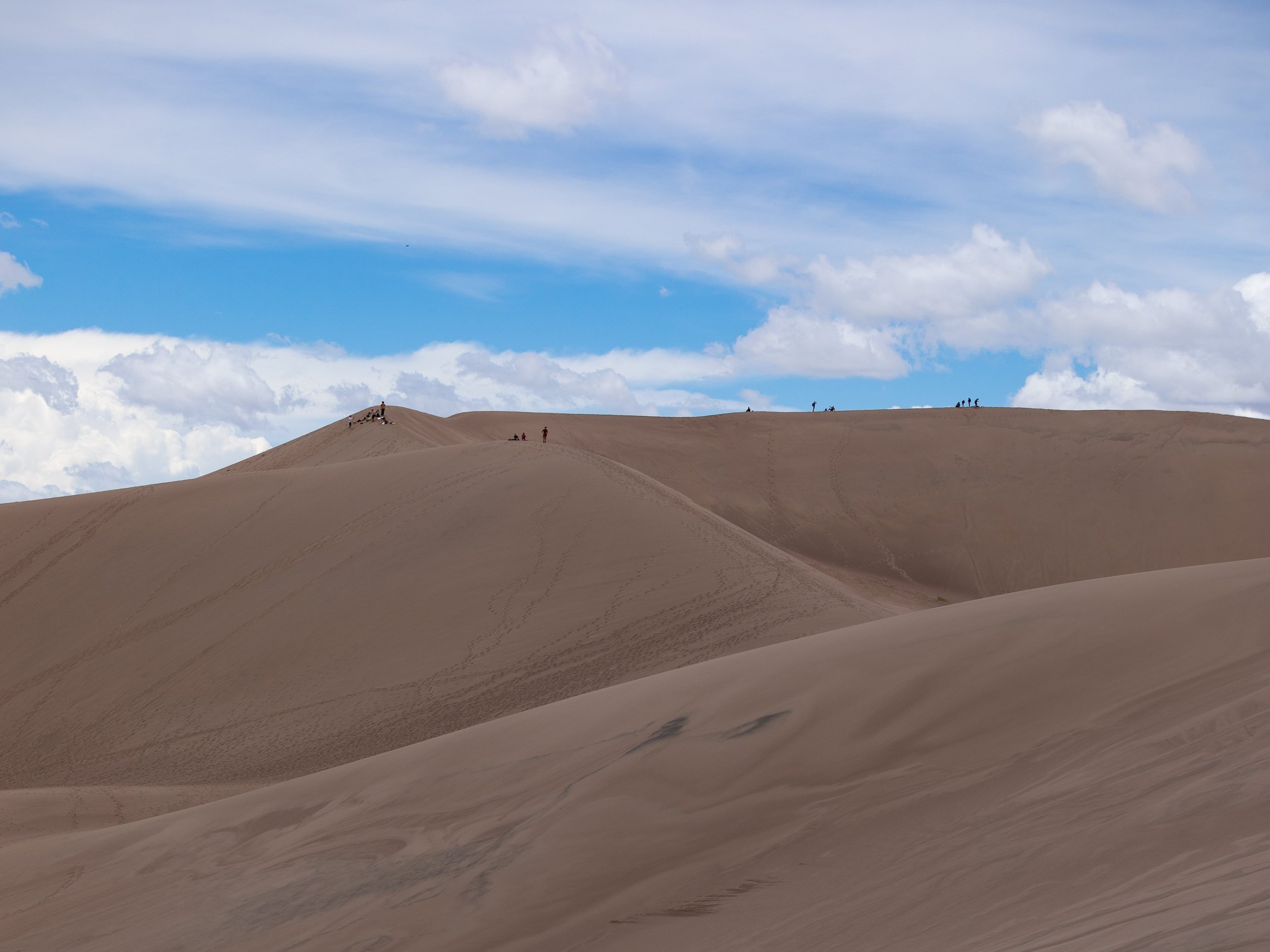
Mesquite Flat Sand Dunes Trail
Length: 2.3 miles
Elevation Gain: 150 feet
Did you know Death Valley has sand dunes?! The Mesquite Flat Sand Dunes are about a half-hour drive north of the rest of the park, but it is worth the drive, in my opinion.
Although you can see the Mesquite Flat Sand Dunes from the parking lot, I recommend hiking to them. Hiking on sand dunes is fun but not as easy as it looks. I had so much sand in my hiking boots after I visited because my feet kept slipping on the sand. It was a very fun experience, though!
Although there is no official trail, you will see where many people hike on the sand dunes and can follow their paths. You can hike as little or as long as you want, too.
If you are up for a sunset exploration, the Mesquite Flat Sand Dunes are a great spot to visit! The views of the sand dunes and surrounding mountains are breathtaking no matter what time of day you visit.
Mosaic Canyon Trail
Length: 3.5 miles
Elevation Gain: 1,000 feet
Mosaic Canyon Trail is one of the most popular hikes in Death Valley for good reason! The trail travels along the canyon floor, through slot canyons, and up rock scrambles while providing incredible views. But the trail is not easy. The terrain and rock scrambles make the hike strenuous, but if you are up for a fun hike, you will love Mosaic Canyon!
The 3.5-mile round-trip trail begins off a two-mile one-way road near Stovepipe Wells. The road is well-maintained but might be difficult for larger campers and RVs. Mosaic Canyon Trail is also not too far from the Mesquite Flat Sand Dunes, so you can hike both while in the area.
Badwater Basin Salt Flats Trail
Length: 2 miles
Elevation Gain: minimal
Did you know Death Valley is home to the lowest place in North America?! Badwater Basin is 282 feet below sea level and has a huge salt flat with stunning views of the surrounding mountains. And the best part? It is an easy walk from the parking lot.
Although you can enjoy the views from the parking lot, I recommend hiking to the boardwalk and onto the salt flats. You can hike as long or as little as you want on the salt flats, which is great! We did not hike too far because there was water from the 2024 floods, but we enjoyed the short hike.
Since Badwater Basin is one of the hottest places in Death Valley, I recommend visiting in the morning to avoid the midday heat. We visited midday in March, and it was very hot!

Darwin Falls Trail
Length: 6.7 miles
Elevation Gain: 670 feet
One of the hottest places in the world has a waterfall?! Yup! Death Valley has a waterfall hidden among its landscapes.
The 6.7-mile round-trip hike begins near Panamint Springs on the western edge of Death Valley. The two-mile one-way dirt road to the trailhead is a bit tough to drive but doable in most vehicles. The road washes out easily, though, so I recommend checking in with a park ranger about road conditions before heading to Darwin Falls!
Darwin Falls Trail is one of the most unique hiking trails in Death Valley because its landscape does not match everything else in the park. The trail is in a pretty lush landscape, especially as you approach Darwin Falls. The waterfall feels like a little oasis hidden in the desert, making it one of the most unique hikes in Death Valley!
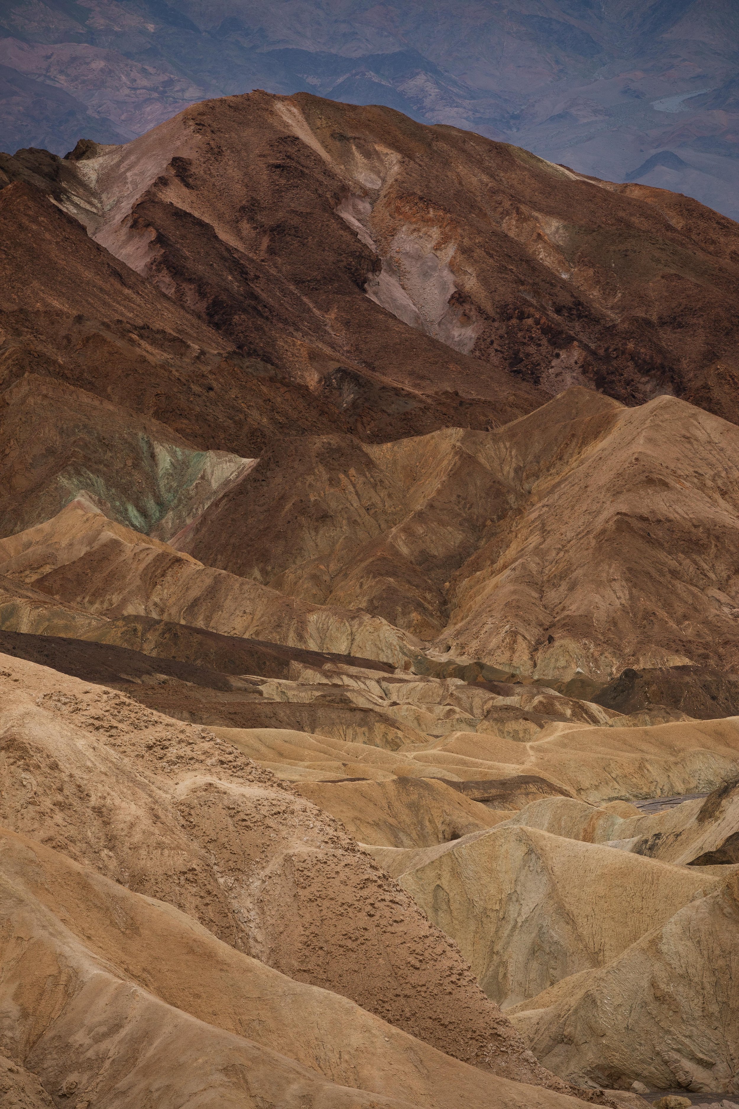
Artists Palette
Length: 0.5 miles
Elevation Gain: 120 feet
Artists Drive should be on every Death Valley bucket list because it is one of the most beautiful areas in the park! The 9-mile, one-way scenic drive has breathtaking multi-colored hills and is one of my favorite areas in the entire park. And it has two easy and stunning hikes!
Artists Palette is one of the most breathtaking areas along Artists Drive. Although the parking lot has a beautiful viewpoint, I recommend walking around the trails to get an up-close and personal experience with the multi-colored hills.
The trail is relatively easy and offers incredible views of Artists Palette. I hiked along every trail in the area because I could not get enough. There are a few areas where most visitors go to get iconic photos, but I recommend traveling around the entire area to enjoy lesser-known viewpoints.
You will quickly fall in love with Artists Palette and see why it is one of the best hikes in Death Valley!


Artists Drive Hill
Length: 0.4 miles
Elevation Gain: 120 feet
The other easy hike along Artists Drive is just over a mile along the road and offers incredible views overlooking the surrounding multi-colored hills. You can enjoy views from the parking lot or walk up a short and steep trail to the viewpoint.
Although the Artists Drive Hill Trail is short, it is steep and makes you work for the views. But the trail is easy to follow, and you will get incredible views at the top, making it worth the effort!
Another trail off this one leads to another beautiful viewpoint if you want to hike longer. But the best views, in my opinion, are on Artists Drive Hill.


Desolation Canyon Trail
Length: 3.6 miles
Elevation Gain: 800 feet
And last but not least, we have another one of the most beautiful hikes in Death Valley. The Desolation Trail is just south of Golden Canyon and has some breathtaking views of the multi-colored hills.
The 3.6-mile round trip hike travels along the canyon floor, gradually ascending to a viewpoint overlooking the salt flats and Artists Drive area. I think the beauty of this trail rivals the beauty of Artists Drive!
The Desolation Canyon Trail is easy to follow and offers incredible up-close views of the multi-colored hills. As you hike further along the trail and the closer you get to Artists Drive, the hills become more vibrant with stunning colors. At the end, you get a beautiful view of the surrounding area looking towards the salt flats.
Desolation Canyon Trail is easily one of the most beautiful hikes in Death Valley and should be on every bucket list!
If you are planning a trip to Death Valley, this guide is the perfect resource. It has everything you need to know about the best hikes in Death Valley that should be on every bucket list!

Hey, I’m Nichole!
I am the creator behind Nichole the Nomad, the home of my explorations around the world, mountain hikes, and beautiful pictures taken along the way. I have a deep passion for capturing the world in a beautiful light and sharing my experiences.
I created this blog to share my travels, show how beautiful the world is, provide tips and tricks for traveling, and encourage you to explore. Whether you want to travel across the world or explore what’s in your backyard, I hope this blog inspires you to get outside and find your adventure!
Pin it for later!

